
PAGASA described Bagyong Ompong as a “very destructive” typhoon and advised Norther Luzon residents to stay indoors. Typhoon Ompong is expected to bring heavy rains and damages to infrastructure and crops.
In anticipation of Typhoon Ompong, over 9,000 people have been moved to temporary shelters Ompong makes its way towards the rice- and corn-producing provinces of Cagayan and Isabela.
Disaster officials warned that tens of thousands more may need to be moved and weather forecasters warned of storm surges as high as 6 meters in coastal villages in the typhoon’s path. Second and third contingents of rescue teams were being prepared, in case first-responders get into trouble themselves.
Below is the complete PAGASA Severe Weather Bulletin #14 as of 2 a.m.:
TYPHOON “OMPONG” HAS MADE LANDFALL IN BAGGAO, CAGAYAN.
TY “OMPONG” has made landfall in Baggao, Cagayan at 1:40 AM (15 September).
The Southwest Monsoon (Habagat) enhanced by the typhoon will bring gusty winds with occasional moderate to heavy rains over Visayas, while scattered light to moderate to at times heavy rains over Palawan, Zamboanga Peninsula, Northern Mindanao and Caraga. Residents in these areas, especially those living near river channels, in low-lying areas and in mountainous areas, are advised to take appropriate actions against possible flooding and landslides, coordinate with local disaster risk reduction and management offices, and to continue monitoring for updates.
Possible Storm surge height in surge prone areas: up to 6 meters in Cagayan and Ilocos Norte; up to 3 meters in Isabela; up to 2 meters in Ilocos Sur, La Union and Pangasinan.
Fisherfolks and those with small seacrafts are advised not to venture out over the seaboards of areas with TCWS and the seaboards of Visayas and of Mindanao.
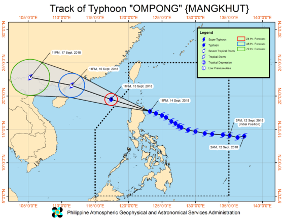
Location of Eye/center
At 1:00 AM today, the eye of Typhoon “OMPONG” was located based Aparri radar and other available data at 90 km East Northeast of Tuguegarao City, Cagayan (17.9 °N, 122.5 °E )
Movement
Moving West Northwest at 35 kph
Strength
Maximum sustained winds of 205 kph near the center and gustiness of up to 285 kph
Forecast Position
24 Hour(Tonight): 365 km West Northwest of Laoag City, Ilocos Norte (OUTSIDE PAR)(19.5°N, 117.4°E)
48 Hour(Sunday evening):1,095 km West of Basco, Batanes (OUTSIDE PAR)(21.6°N, 111.5°E)
72 Hour(Monday evening): 1,745 km West Northwest of Basco, Batanes (OUTSIDE PAR)(22.8°N, 105.3°E)
Warning Signal
Tropical Cyclone Warning Signal no. 4
AFFECTED AREAS
Luzon
Ilocos Norte
Cagayan
northern Isabela
Apayao
Abra
Kalinga
Babuyan Group of Islands
Tropical Cyclone Warning Signal no. 3
AFFECTED AREAS
Luzon
Batanes
southern Isabela
Ilocos Sur
La Union
Mountain Province
Benguet
Ifugao
Nueva Vizcaya
Quirino
Northern Aurora
Tropical Cyclone Warning Signal no. 2
AFFECTED AREAS
Luzon
Pangasinan
Tarlac
Nueva Ecija
southern Aurora
Zambales
Pampanga
Bulacan
Northern Quezon incl. Polillo Is.
Tropical Cyclone Warning Signal no. 1
AFFECTED AREAS
Luzon
Bataan
Rizal
Metro Manila
Cavite
Batangas
Laguna
Rest of Quezon
Lubang Is.
Marinduque
Camarines Norte
Camarines Sur
Catanduanes
Albay
Burias Island
Visayas
Mindanao