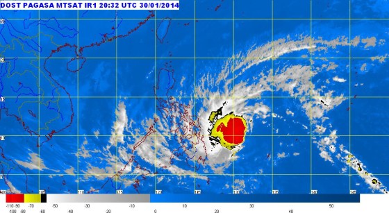
Typhoon Basyang Update
Credit: PAGASA
The latest update on Typhoon Basyang by the Philippine Atmospheric, Geophysical and Astronomical Services Administration (PAGASA) indicated that it is now heading towards Surigao Provinces. Tropical storm “Basyang” is reportedly approaching the eastern seaboard of the Philippines.
Basyang was earlier spotted at 768 kilometers east northeast of Hinatuan, Surigao del Sur. PAGASA weather forecast indicates that Bagyong Basyang will make a landfall between 11 p.m. Friday and 2 a.m. Saturday.
Typhoon Basyang has a maximum sustained winds of 55 kilometers per hour (kph) near the center as it moves in western direction at 30 kph.
As of posting, public storm signal number 1 was raised over 19 areas in Visayas and Mindanao. The following areas are now under public storm warning signal number 1.
- Southern Samar,
- Southern part of Eastern Samar,
- Leyte,
- Biliran,
- Southern Leyte,
- Camotes Islands,
- Cebu,
- Negros Occidental,
- Negros Oriental,
- Siquijor Island,
- Bohol,
- Surigao del Norte,
- Siargao Island,
- Surigao del Sur,
- Northern part of Agusan del Sur,
- Agusan del Norte,
- Camiguin Island,
- Dinagat Islands,
- Misamis Oriental.
PAGASA is warning residents in the affected areas for possible flash floods and landslides. The weather bureau is extimating 5 to 15 millimeters per hour (moderate – heavy) of rainfall.
More updates on Typhoon Basyang will be posted on this site once they are made available by PAGASA.
